3 Maps That Explain Why South America Is Politically Isolated
- Meredith Friedman
- |
- March 30, 2017
- |
- Comments
BY GEORGE FRIEDMAN
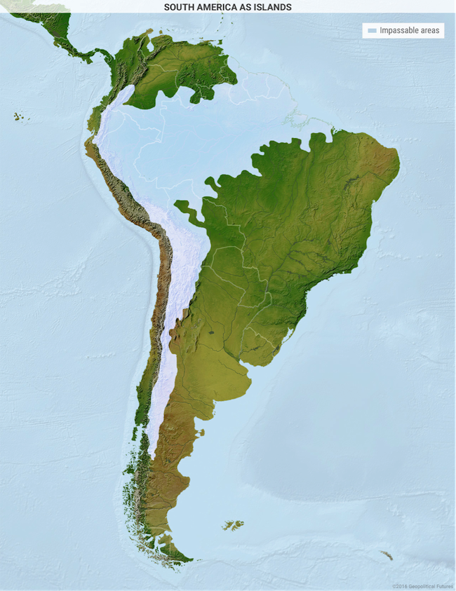
What makes South America stand out is that it looks like a large island. Oceans split it from others by great lengths.
Mexico, Central America, and the Caribbean make a divide between South America and the US. Plus, it is split by the Amazon rainforest and Andes Mountains to form two “islands.”
This has affected the growth of warfare, trade, and regional leadership in South America. Below are four maps that explain the roots of South America’s colonization and wealth.
South America Has Geography Like Nowhere Else
This island feature is one of three geographic quirks that has lowered the risk of modern war between local states.

The second one is South America’s placement in the Western and Southern hemispheres. This lessens the risk from world wars. The continent is far from Eurasia, which—as we’ve written about previously—is where many of the worst wars have been waged. It has largely kept itself from being drawn into these.
The third quirk is that physical walls—like the Amazon, the Andes, the Atacama Desert, the Pantanal wetland, and the Gran Chaco—align with national borders. This lowers the chance of war.
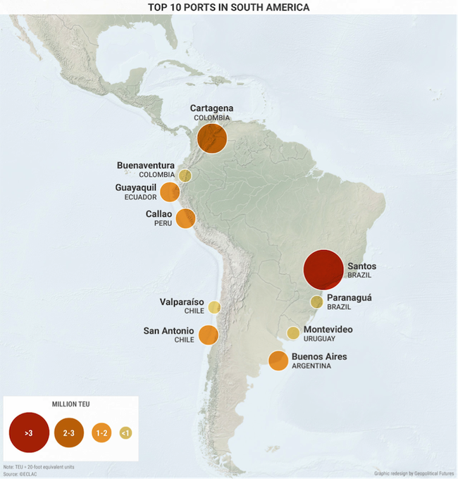
Geography has also helped South America’s need for extra-regional exports. Tough terrain made sea trade and the building of ports a must. Also, due to colonization, these ports played a big role in national economies.
Colonial powers wanted raw material exports promptly shipped to Europe. Still, many countries in South America depend on the export of raw materials from ports for funds.
South American Geography Determined Its Colonization and Regional Powers

Both colonization and geography explain why there is no clear regional leader.
It’s easy to recognize that Brazil is seen as the emerging leader, but this is mostly due to its size in terms of land, population, natural resources, and economy.
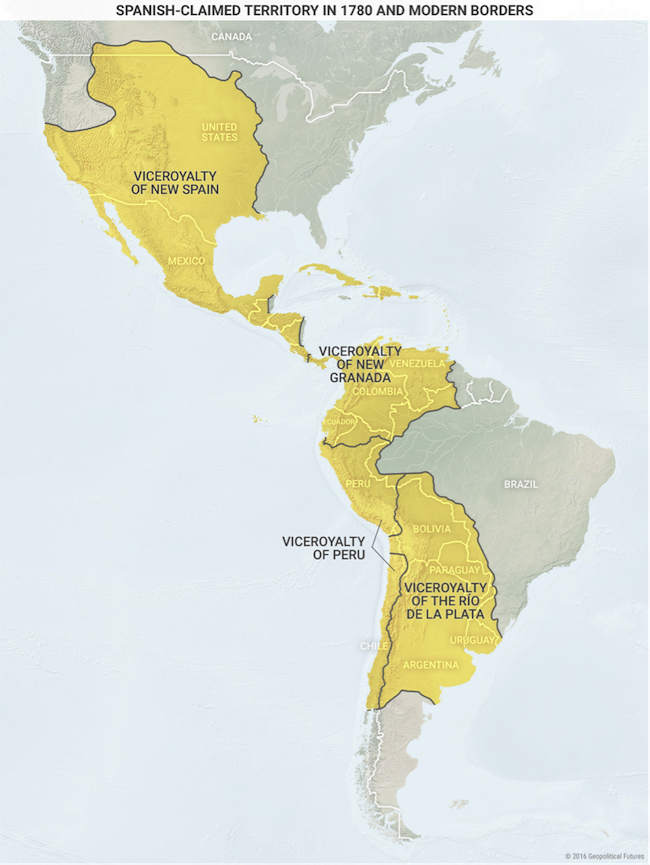
Argentina, also rich, is its historic rival and serves as a balance. This is because Brazil was colonized by the Portuguese and Argentina by the Spanish.
The Amazon and Pantanal kept most of Brazil from the Spanish viceroys.

This let them build their state on other terms than the rest of the region. During the first colonization, control of the borderlands between Brazil and Argentina changed hands often.
Bolivia, Paraguay, and Uruguay are called buffer states between Brazil and Argentina. But both countries lack access to the Pacific Coast. Brazil due to the Amazon and Argentina due to the Andes.
South America Has Not Found a Regional Leader
That’s because no one country can take on the role, even though some have large populations, land, and natural resource deposits. The Andes and Amazon divide the continent. This makes it hard to access the Atlantic and Pacific, except for Colombia.
Colombia’s mountains run straight through the country. This makes internal logistics and transportation very hard. This lowers the economic and security benefits of dual ocean access.
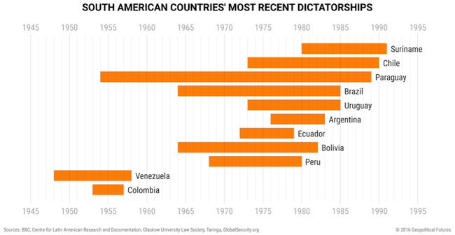
The region’s growth has also been slowed by military dictatorships and social revolutions in the 20th century.

Almost every South American country had a military dictatorship in the 20th century. Many did not end until the late 20th century.
This makes the current democracies young and untested.
Isolated from the World
Real distance from the world plays a strong role in foreign relations. South America is far from big trade routes in the North. It is far from Europe and Asia. To gain more power, South American countries have tried to place themselves more in the world system.
This plan is a constant in their foreign policies. Regional integration groups serve as tools for these states to gain more clout to use in world affairs.
Larger countries also develop expertise through which they can put themselves into world issues. For example, Argentina with nuclear energy, Peru with climate change, Chile with mining, and Brazil with deep-water oil drilling.
This has useful local uses, but also is a way to move more into the world system.
Grab George Friedman's Exclusive eBook, The World Explained in Maps
The World Explained in Maps reveals the panorama of geopolitical landscapes influencing today's governments and global financial systems. Don't miss this chance to prepare for the year ahead with the straight facts about every major country’s and region's current geopolitical climate. You won't find political rhetoric or media hype here.
The World Explained in Maps is an essential guide for every investor as 2017 takes shape. Get your copy now—free!
